The highest surface on the rocky hill of Oglanqala is marked by the remains of stone walls that once formed a major monumental building complex. In 2008 the Oglanqala project opened two 10 meter by 10 meter excavation units (operations A and B), as well as a 2.5 by 2 meter sounding (operation D), adjacent to the excavations undertaken by Veli Bakhshaliyev in 1988.
Earlier Excavation
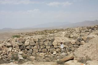
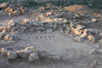
The 1988 excavation was laid out following the orientation of two substantial stone walls which were visible on the surface. These masonry walls—built of very large, roughly-finished masonry with smaller stones wedged between large trimmed stone blocks—created the northern and western borders of the operation (Figure 1).
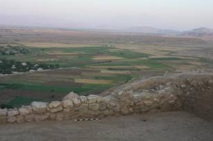
This construction technique is found widely at Oglanqala in association with the outer fortification and tower walls, which are probably contemporary with this wall. It is also well attested at a variety of other Iron Age fortress sites including Bastam, Ayanis and Hasanlu III. The wall that lines the western end of the citadel is made of smaller unfinished stones of a variety of sizes with mud mortar filling in the gaps between the masonry (Figure 2). This wall appears to be less well-made than the northern wall but is also in keeping with fortress architecture of the 8th to 6th centuries BC.
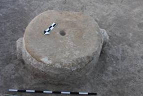
The 1988 excavations revealed that the western wall was built on fill that runs up against the northern wall, and is thus probably a later addition. Bakhshaliyev identifies four building periods in the citadel area. The latest construction phase, probably dating to the medieval to modern periods, consists of the remains of walls made of unfinished stone that directly parallel the stone enclosures found in 2008 in Operations A and B. The phasing of the following three construction periods is complicated by the fact that in the eastern half of the excavation bedrock was apparently reached at a depth of only about 1.5 meters whereas in the western portion of the square occupation extended to at least 3 meters below the surface. Bakhshaliyev assigns two square, stone column plinths, one base and two drums to construction phase 3 and one plinth to construction phase 4 on the basis of their absolute levels, but it is possible that a single building or portico simply stepped down at this point and that all of these stone column elements belonged to the same architectural complex (Figure 3 and Figure 4).
The 2008 Excavations
Operations A and B
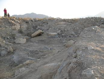
In 2008, we laid out Operations A and B to the south of Bakhshaliyev’s old excavation area, with the western edge of Operation A again running along the western wall that had been uncovered in the old excavation. The surface of operations A and B was dotted with unfinished stones that sometimes formed circular enclosures. These stone enclosures may have been the remains of huts or animal pens built by pastoralists in the medieval or later periods, although, with the exception of a few grinding stones and ash concentrations, there was little evidence for any cultural activity associated with these stone circles. Four modern burials containing gun cartridges, buck shot, and Russian-made ceramics were sunk into these stone enclosures (Figure 5).
The Columned Building
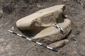
In Operation B, one stone column drum was found at the same level as the stone enclosures in what was clearly a secondary context (Figure 6). This column drum, which would have made a perfect table, may have been moved and reused by the pastoralists who built the stone enclosures, or it may simply have been left where it lay in the fill when the column collapsed and been used opportunistically by the newcomers. An almost identical column drum was recovered at approximately the same level lying on its side at the very edge of the Operation A square, such that most of the drum actually remained, seemingly suspended, in the baulk of the square (Figure 7). Again this drum was clearly not in situ, but it is not clear if it had been moved here by later occupants, had rolled to this spot in the course of surface erosion, or simply lay where it had fallen when the column collapsed.
These two column drums, along with three others excavated by Bakhshaliyev in 1988, are very unusual in shape and finish, with two large opposing bosses along their outer edges. These are similar to the lifting bosses of Greek and Achaemenid masonry, but here they appear to have been left intact when the column was in use. The stone surface at the top and bottom of the drums, where superimposed drums would have met, is smoothed, but the sides of the drums, which should have been visible when the columns were intact, are only very roughly trimmed. The drum from Operation B still had hard white plaster adhering to its outer surface, and we assume that a very thick layer of plaster or some other covering such as brick or tile would have obscured the side bosses so that the final effect was a smooth column surface. The bosses themselves may have been left in place after the columns were assembled in order to secure this outer covering better. We can find no good parallel to these unusual column drums. An apparent column capital with similar side bosses but with drafted margins on its top surface was also found in Operation A (Figure 8). The small size of this capital makes it unlikely that it was originally attached to the recovered column drums, unless the columns tapered dramatically towards the top.
The stone column capital, base, drums and plinths recovered in seemingly secondary context in the 1988 and 2008 excavations all seem to belong to a monumental building complex, but we have found nothing yet that would give us any indication of the plan or nature of this building or even its chronological or cultural context. We assume that it is connected to the late to post-Achaemenid pottery that was found in small numbers in the upper fill in Operations A, B and D (Figure 9 and Figure 10), and in larger amounts in the surface survey of the site as well as in Operation C, but there is as yet no clear stratigraphic sequence that would allow us to make this connection unequivocally. Further excavation should help to clarify the plan and date of this monumental columned structure.
Iron Age Occupation in Operation A
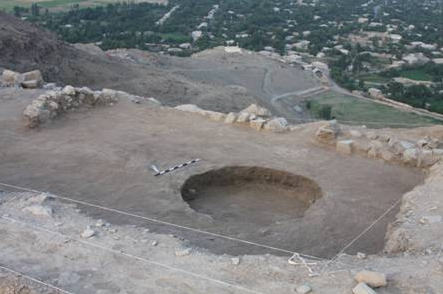
In Operation A, below the level of the fallen column drum, a series of pits and hearths were sunk into sloping fill or abandonment/erosion strata. These deposits ran up against the western wall and must have been deposited after that wall had already gone out of use. It was impossible to identify clear floors associated with these features, which were built into sloping exterior surfaces. One very large hearth contained the remains of what appeared to be a sizable feast with numerous charred cooking pots, a whole bowl and a large quantity of animal bone (Figure 11). At the close of the 2008 season excavations in Operation A had not yet reached an occupation level associated with Wall E.
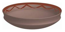
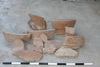
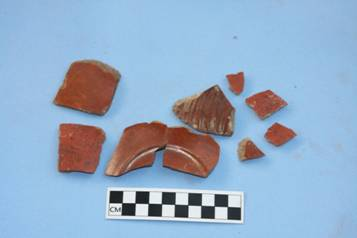
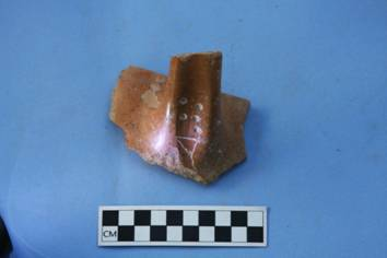
The pottery in these deposits included many sherds of large storage jars with molded decoration similar to those found at Bastam and Ayanis in the 7th century BC (Figure 12). We also recovered a few sherds of very finely polished red-ware with strong links to the “palace-ware” found at these sites (Figure 13). A jar handle with impressed circles and an incised wedge-shaped triangle also provides a link to Urartian-period citadels (Figure 14).
The Deep Sounding of Operation D
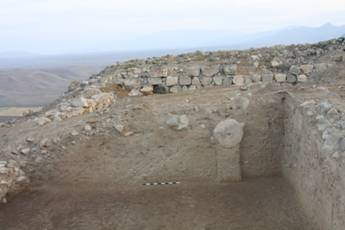
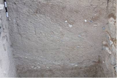
Operation D was a 2.5 by 2 meter sounding that was placed between the old and new excavations in order to obtain a complete stratigraphic sequence of the citadel area. In the small area of Operation D the sloping surfaces that were encountered in Operation A were easier to identify and define. Each stratum sloped slightly from north to south and sharply from east to west, following the slope of the hilltop (Figure 15). All clearly ran up against the western wall and were almost certainly deposited after the latter had gone out of use. These deposits were composed of debris that appeared to have eroded from mud-brick architecture or features and washed down the slope to the wall.
These erosion layers included many sherds of very large storage jars including one complete flat base and two fragments with very precisely impressed Urartian-period cuneiform signs. Lying below these sloping strata and the bottom of the western wall, was a 70cm thick platform made of clayey fill, topped by a layer of untempered well-levigated clay bricks (Figure 16). The western wall was built on top of this flat level of clay which seems to have served as a foundation to the wall and perhaps to the building as a whole. Some rocks and one large, burnt brick lay on top of this platform, which appears to have served as the floor to this area when it was in use, since no other floor could be detected. Between the platform and the bedrock of the hill was a more than two-meter layer of clayey fill that included lenses of pebbles and larger rocks. Unlike the steeply sloping strata that accumulated over the platform, under the platform the deposits were more or less level or followed the tip lines of deliberate fill. Large sherds of very large storage jars continued to appear in these fill levels, which may have been the remains of leveling operations undertaken before the construction of the western wall. We anticipate finding this platform and leveling fill in Operation A when excavations are continued next season.