Our third goal during the 2011 season was the excavation of the citadel. This 1.2 ha area probably contains two buildings which formed the administrative core of this area from 800-250 BC, during Oğlanqala periods III and IV. The main citadel building is in the north and covers an area of about 4700 m2. Work here during the Soviet excavations from 1988-1989 and our previous excavations during 2008-2010 had already exposed ca. 1800m2 of this building (Figure 11). During 2011, we reopened excavations in two of the squares that were initially excavated at the very end of the 2010 season and also initiated excavations in a new 10X10m2.
Radiocarbon analysis indicates that the citadel was first constructed around 800 BC at the beginning of Oğlanqala IV, coincident with the building of the fortification walls and towers.1 The same construction techniques used in the fortifications were employed at the citadel, including the presence of worked limestone blocks between 35 and 90 cm2. Similarly, these walls were founded on bedrock, which had sometimes been covered with a clay or concrete surface and had a mudbrick superstructure, although most of this had eroded away. Like the fortification walls, most of the citadel walls had a rubble core. They ranged in width from 1.7-2.5 m. The Oğlanqala IV building was arrayed around a very large square courtyard, 33 X 34 m, or 1122 m2. This makes it almost identical in size and shape to the courtyard surrounding the temple at Altıntepe, Turkey. 2 The courtyard was probably one of the main public spaces in the citadel. Its imposing size would have displayed the political power of the ruler of the fortress. East of the courtyard were a series of long narrow rooms. Because of the height of the bedrock in this area, we only recovered their foundations and have little evidence for their function. It is possible that they were storage rooms or other offices for the palace. On the southeast side of the building was a lone square buttress, while a possible circular tower could be traced on its southwest side.
In the Period IV courtyard we found evidence of the administrative function of the building, in the form of large storage jars and the oldest writing found in excavation in Azerbaijan, cuneiform inscribed sherds. Although no complete storage jars were found, storage jar sherds with their arrow molded decoration and occasional cuneiform inscriptions were found in almost every area and context. The fragmentary signs found on the storage jars probably recorded vessel capacity. We can reconstruct numbers as well as the common signs a-q[ar] and ru, which likely came from the words aqarqi and terusi, two volume measurements.3
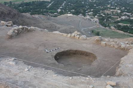
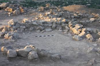
During the 2011 season, we focused our work on the eastern side of the building. Excavation at the end of the 2010 season had traced part of the Period IV Citadel Fortification on the east, exposing an unusual gap, where these walls turned west. The area between these walls was irregular, widening towards the east, from 6.5 to 7.5 m. It seemed possible that this construction was part of a recessed entrance, perhaps the main entry to the citadel. The western limit of this area was a Period III wall, W-S, which blocked the purported entrance. We opened excavations here to clarify the relationship between the eastern fortification walls and the palace. Below W-S we found an earlier wall that incorporated some of the finest masonry yet recovered at the site (Figure 12). Although most of W-S was built of standard, roughly-shaped limestone blocks, like those seen in other Period IV walls at the citadel and in the fortifications, this wall also incorporated seven carefully shaped ashlar blocks in two standardized of 90X60 cm and 45X60 cm. W-S returned off of W-A, and the southern corner of both walls was made from limestone ashlar blocks with square bosses. Similarly shaped blocks have been recovered at Urartian sites in Turkey and northwest Iran including Bastam, Toprakkale, Çavuştepe and Ayanis.4 At Bastam and Çavuştepe these rusticated blocks, dressed evenly around the edges but with a rough boss in the center, are used as foundations of the outer walls of administrative buildings, as at Oğlanqala. At Toprakkale these blocks forms the platform upon which the temple of Haldi was constructed. At Ayanis, such a technique was used for the foundations of the southern citadel fortification wall. All of these sites are 7th century foundations, and Erzen dates this building technique to that period. At Oğlanqala, it is possible that these blocks were taken from elsewhere to strengthen this corner during a 7th century (or later) reconstruction or repair of the citadel. It is possible that this area provided a platform for a major building that has unfortunately eroded away, or it could have been part of a gate construction. A least-cost analysis of the easiest path up the citadel shows that this would be a good place for a northern facing gate, but excavation south of W-S failed to locate the southern limits of this entry. Further work is needed in this area to clarify the plan of the Period IV palace.
The Oğlanqala citadel was probably abandoned briefly sometime after the 7th century. Our next evidence for occupation here dates to some time between 400 and 250 BC, when Period III architects rebuilt this palace. The Period III palace occupied the same area and followed the same general alignment as the earlier structure. Few of its walls are direct rebuilds of early Period IV architecture, although the northern, southern and eastern walls of the courtyard (W-A, W-C and W-E) were reused in the Period III building. In general, rooms in the Period III palace are smaller and more numerous. Period III masonry is also less impressive than its Period IV counterparts. Period III wall foundations are built of smaller, almost entirely unworked stones, set in a mud mortar. Smaller stones are no longer used as chinking, and walls are generally narrower than their Period IV counterparts, ranging from 1-2 m wide, but with most constructions closer to 1m. There is stratigraphic evidence that the Period III architects excavated down to bedrock in much of the citadel, disturbing earlier Period IV deposits. They then filled the space left between the Period IV foundation walls with either rubble fill or a mudbrick pavement and constructed the Period III walls on this surface, rather than on bedrock. Although the foundations looked less impressive than their earlier counterparts, there is evidence that the finished walls may have been more beautiful. Ashlar masonry has been found in various places in this building, often providing a smooth facing to Period III walls like W-A and W-E. These ashlar blocks are generally made from tufaceous limestone or sandstone, not the marbleized limestone which comprises the bedrock of Karatəpə and that was used for most of the architecture.
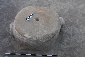
The largest space and focal point of this building was a large room, in the same place as the earlier courtyard. This Period III room was slightly smaller than its Period IV counterpart, measuring 27X33m. There is some evidence, in the form of 29 column elements scattered in the northern half of this room, that the Period III architects had planned to construct a columned hall in place of the older open courtyard. These elements represent drums, bases, capitals and perhaps square plinths (or column blanks). None of the elements were finished; lifting bosses were still attached to the drums, and none of the elements had been smoothed, polished or prepared for final decoration. There are not enough column elements to provide full columns throughout this large space, in the manner of an Achaemenid apadana. Given their unfinished state, however, as well as the unfinished state of most of the building, it is hard to discern precisely how these columns would have been incorporated into this architectural space.
Columned halls are well-known from much of the Near East at this time, with several excavated examples from the Caucasus and Eastern Turkey. The Oğlanqala hall is smaller than those at Altıntepe and Erebuni, both of which were probably satrapal capitals, although its shape and dimensions are similar.8 Despite the difficulties in finding exact parallels for the Oğlanqala column elements, given their unfinished state, two of the bell-shaped column bases are similar in size and general shape to those found at excavations in Qaracəmirli, Sarı Təpə, Gumbati, and Benjamin.9 The other column elements, such as an unfinished torus and partially carved lower column drums, may have parallels from 2nd century contexts at Seleucid Nahavand, Iran and Seleucid/Greco-Bactrian Ai Khanoum, Afghanistan.10 A post-Achaemenid context is probably a better fit for a site with stone column drums and capitals in addition to bases. Outside of the Achaemenid capitals in Fars, Satrapal and provincial capitals probably made do with wooden or mudbrick columns on stone bases, judging from the absence of other elements in excavated contexts. Our radiocarbon samples from the discontinuous ashy surface where most of the column elements were found and from the base of the Period III walls indicate a probable 4th or 3rd century date for this construction.
The radiocarbon dates, parallels for the columns and some associated pottery indicate that the reconstruction project could coincide with either of two historical periods, either the last 50 years of the Achaemenid Empire or the immediately post-Achamenid period when Seleucus was consolidating his empire. In this case, the abandonment of the project could result from the death of Darius III and the fall of the Achaemenid empire or alternatively from Alexander’s unexpected demise. Second, it may date to the period immediately after the fall of the empire, during the chaotic decades at the end of the 4th century and the reorganization of this territory into Media Atropatene. Given the many local features of the citadel at Oğlanqala, it may be most likely that the construction of this building dates to the second period. Oğlanqala is strikingly different from other Achaemenid sites—including other sites in the Caucasus like Qaracəmirli, Gumbati and Benjamin, which often look very like sites in Persia itself. At Oğlanqala, certain symbols of authority—like the massive columned hall—were adopted but rendered in a local style. The person who ordered its construction may have been a local strong man seeking to consolidate his rule over the Şərur plains or perhaps a larger area. His ascendancy probably did not last long, and the building project, site, and indeed landscape of fortresses were abandoned. Iron arrowheads and slingshot stones were found in the ruins of this building, and highlight the probable violent destruction of this phase. Evidence for the strong influence of Achaemenid styles in the Caucasus after the fall of the empire has been clearly demonstrated, particularly in excavations in Colchis in Western Georgia like Vani. It is possible that Oğlanqala represents a parallel case.11
The final evidence for construction at the citadel dates to Period II. More than 30 pits were cut into the ruins of the Period III palace. Their unusual contents may be related to feasting or other specialized activities and indicate that centuries after the abandonment of this building, the monumental architecture of the palace was part of the daily life of Oğlanqala’s inhabitants. Geophysical analysis elsewhere on the mound indicates that from ca. 100 BC-100 AD, Oğlanqala was the site of a fortified town, perhaps Olâne, a town in the Caucasus which is mentioned in Strabo.12 Large numbers of two room houses arranged on alleys and roads were visible on the magnetometry analysis, along with one larger house, perhaps a villa (Figure 13).


